Char Dham
According to the Hindu scriptures, the holy centres of Gangotri, Yamunotri, Badrinath and Kedarnath - collectively called the Char dham (meaning the four sacred spots) - are the most sacred of all the pilgrimages. Undertaking a journey to these places will not just wash away one's sins but ensure release from the cycle of birth and death. The honour conferred on these places is not surprising. For one, they are all in the icy Garhwal ranges and regarded as the most sacred of all Himalayan ranges. It is also said that heaven and earth converge in these holy spots, and to be born or die here is a boon only the very fortunate have. The Chardham must be visited from left to right -beginning with Yamunotri, going on to Gangotri, Kedarnath and culminating the journey at Badrinath. This route follows the Hindu tradition of parikrama or clockwise circumambulation.
Owing to the significance of this religious circuit, devotees from all over the world, come here to experience the eternal bliss. Char Dhams are hustling and bustling with activity during the summer months, as hundreds of devotees embark upon the holy journey. The picturesque surroundings of the mountainous region are simply enthralling, giving the visitors a perfect opportunity to unwind themselves by filling their lungs with fresh air. Moreover, these otherwise silent and tranquil locales resound with the names of the Lord as the pilgrims advance towards their destination.
Yamunotri
The shrine of Yamunotri, situated at an elevation of about 3,235 m is a point of paramount religious importance for Hindus and an essential pilgrimage. Situated in the direction opposite to Gangotri, the road bifurcates from a place called Dharasu, somewhere between Rishikesh-Uttarkashi and goes on to Yamunotri. The shrine can also be visited via Mussoorie and Barkot.
General Information :-
| Altitude | : | 3,235 m. |
| Climate | ||
| Summers | : | Cool during the day and cold at night. |
Winters | : | Snow-bound. Touching sub-zero. |
| Clothing | ||
| Summers | : | Light woollens. |
Winters | : | Very heavy woollens. |
| Languages | : | Hindi, Garhwali and English. |
| Eating Out | : | Only local eating houses (dhabas) are available. Non-vegetarian food and alcoholic drinks are prohibited in Yamunotri. |
Attractions of Yamunotri
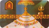
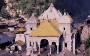
- Yamunotri Temple
The main temple is dedicated to Goddess Yamuna. The present temple was built by Maharani Guleria of Jaipur in the late nineteenth century. Once destroyed by an earthquake, it has been rebuilt. A holy dip in the nearby tank filled by hot springs and cooking rice in its water are common rituals performed by the devotees. - Surya Kund
One of the important thermal springs known for its very high temperature of 190°F. Pilgrims cook rice and potatoes here to offer to the deity in the temple. - Divya Shila
A huge rock pillar venerated before entering the Yamunotri Temple. - Hanumanchatti
The confluence of Hanuman Ganga and Yamuna rivers forms the starting point for the scenic Dodi TaL Trek. - Sayanachatti
A scenic spot along the banks of river Yamuna that makes a lovely sight enroute the trek upto Yamunotri. - Chamba
A sylvan spot on way to Tehri that offers an excellent view of the Himalayan peaks. Situated at an altitude of 1,676 mts., Chamba is an ideal summer retreat.
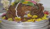
Photos of Yamunotri
 |  |
| Yamunotri Temple | Yamunotri - Char Dham |
How to Reach Yamunotri:
| Air | : | Nearest airport is Jolly Grant, Dehradun. |
| Rail | : | Nearest railhead is at Rishikesh. |
| Road | : | The road to Yamunotri diverts from Dharasu bifurcation point. Important road distances: Hanuman Chatti (13 km), Dharasu (107 km). Tehri (149 km). Hanuman Chatti to Phool Chatti is 5 km by jeep, 3 km Phool Chatti to Janki Chatti on foot and 5 km from Janki Chatti to Yamunotri by trek (8 km trek), the roadhead for Yamunotri is connected by bus services of Samyukt Rotation Yatayat Vyavstha Samiti to Rishikesh, Haridwar and other major centres in the region. Important Road Distances: Rishikesh to Yamunotri 222 km. via Narendranagar 16 km, Chama 46 km, Brahmkhal 15 km, Barkot 40 km, Sayana Chatti 27 km, Hanuman Chatti 6 km, Phool Chatti 5 km, Janki Chatti 3 km and Yamunotri 6 km. |
State Tourism Accommodation
- Tourist Rest House, Jankichatti (GMVN).
- Tourist Rest House, Yamunotri, ( GMVN) - provides for only dormitory accommodation
Tourist Information Centre
Yatra Office: Yatra Office, GMVN Ltd., AGM (Tourism), Modern Reception Centre
(Advance Reservation Centre)
Shail Vihar, Haridwar By-Pass Road, Rishikesh, Pin: 249201.
Tel: 91-135-2431793, 2432648, 2430799, 2430357(R).
Fax: 0135-2430372.
Email: yatra@gmvnl.com, yatraoffice@sancharnet.in.
Gangotri
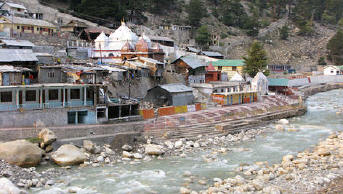
Gangotri, the source of the river Ganga and seat of the goddess Ganga, is one of the four sites in the Char Dham pilgrimage circuit. The river is called Bhagirathi at the source and acquires the name Ganga from Devprayag onwards where it meets the Alaknanda. The origin of the holy river is at Gaumukh, set in the Gangotri Glacier, and is a 19 km trek from Gangotri. Gangotri can be reached in one day's travel from Rishikesh, Haridwar or Dehradun, or in two days from Yamunotri, the first site in the Char Dham circuit. More popular and important than its sister site to the east, Gangotri is also accessible directly by car and bus, meaning that it sees many more pilgrims than Yamunotri.
This small town is centered around a temple of the goddess Ganga, which was built by the Gurkha General Amar Singh Thapa in the late 18th or early 19th century. The temple is closed on Diwali day every year and is reopened in May. During this time, the idol of the goddess is kept at Mukhba village, near Harsil.
Ritual duties are supervised by the Semwal family of pujaris. The aarti ceremony at the Gangotri is especially impressive, as is the temple, a stately affair that sits on the banks of the rushing Ganga. Adventurous pilgrims can make an overnight 18 km trek to Gaumukh, the actual current source of the river Ganga.
For a large number of tourists, Gangotri town serves as the starting point of the Gangotri-Gaumukh-Tapovan and Gangotri-Kedartal trekking routes.
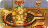
Photos of Gangotri
 |  | |
| Gangotri Temple | Gangotri Temple |
Mythological Relation
According to Hindu mythology, Goddess Ganga - the daughter of heaven, took the form of a river to absolve the sins of King Bhagirath's predecessors, following his severe penance of several centuries. Lord Shiva received Ganga into his matted locks to minimize the impact of her fall.
According to this legend, King Sagar, after slaying the demons on earth decided to stage in Ashwamegh Yagya as a proclamation of his supremacy. The horse which was to be taken on an uninterrupted journey around the earth was to be accompanied by the King's 60,000 sons born to Queen Sumati and one son Asmanjas born of the second queen Kesani. Indra, supreme ruler of the gods feared that he might be deprived of his celestial throne if the 'Yagya' (worship with fire) succeeded and then took away the horse and tied it to the ashram of Sage Kapil, who was then in deep meditation. The sons of the King Sagar searched for the horse and finally found it tied near the meditating sage. Sixty thousand angry sons of King Sagar stormed the ashram of sage Kapil. When he opened his eyes, 60,000 sons had perished by the curse of sage Kapil. Bhagirath, grand son of King Sagar, is believed to have meditated to bring down the Ganga to cleanse the ashes of his ancestors and liberate their souls, granting them salvation or Moksha. The Bhagirathi 'Shila' is located near the temple of Ganga where the holy Ganga first descended on earth from heaven.
General Information :-
Altitude : 3042 mts.
Climate : Summer - Cool during the day and cold at night.
Winter - Snow-bound. Touching sub-zero.
Clothing : Summer - Light woollen
Winter - Very heavy woollen.
Language : Hindi, Garhwali & English.
Season : April to November.
Attractions of Gangotri
Gangotri templeThe 18th century’s temple dedicated to Goddess Ganga is located near a sacred stone where Kind Bhagirath worshipped Lord Shiva. Ganga is believed to have touched earth at this spot. According to another legend, Pandavas performed the great ‘Deva Yagna’ here to atone the deaths of their kinsmen in the epic battle of Mahabharata.The temple is an exquisite 20 ft. high structure made of white granite.
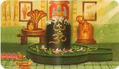
Submerged Shivling
The natural rock Shivling, submerged in the river, is an amazing sight reinforcing the power of the divine. According to mythology, Lord Shiva sat at this spot to receive the Ganga in his matted locks. The shivling is visible in the early winters when the water level goes down.
Accessibility / How to reach :-
Airport : Jolly Grant, Dehradun 226 kms.
Railhead : Rishikesh, 249 kms.
Road : Well connected to Rishikesh, Haridwar, Dehradun and Delhi.
Important Road Distances :
Dharasu ( 129 Km.), Yamunotri (224 Km.) Mussoorie ( 247 Km.), Tehri ( 172 Km.)
Accommodation in Gangotri
A number of Ashrams along the banks of Bhagirathi, Tourist Rest House, PWD Inspection House, Forest Rest House are available. Dharamshalas, Guest Houses and Private Hotels also ensure convenient accommodation
Where to Eat in Gangotri
Only local eating places (dhabas) are available. Non-vegetarian food and alcoholic drinks are prohibited in Gangotri.
ENROUTE
- Agrakhal, Tehri-Rishikesh route.
- Chinyalisaur, Uttarkashi-Chamba route
- Naitala near Uttarkashi-Gangotri root
- Ginoti, Dharasu-Yamunotri route.
EXCURSIONS
Nandavan Tapovan ( 6 kms. )
An arduous trek along the Gangotri Glacier leads to scenic Nandanvan - the base camp for the Bhagirathi peaks, that offers a panoramic view of the surrounding Shivling peak. A trek across the snout of the Gangotri Glacier leads to Tapovan known for its beautiful meadows that encircle the base of the Shivling peak.
Uttarkashi ( 99 kms.)
An important pilgrimage centre, situated at an elevation of 1,150 mts. above sea level on the bank of river Bhagirathi. Some of the important temples worth visiting are - Vishwanath temple, Ekadash Rudra temple, Gyaneshwar temple and Kuteti Devi Temple. Nearby is the Nehru Institute of Mountaineering. Every year, during the ‘Magh Mela’ ( January 14 ), people visit Uttarkashi to take a holy dip in Bhagirathi along with the image of their village deity.
Kedar Tal ( 18 kms.)
An enchanting lake, 4425 mts. above sea level against the splendid backdrop of mighty Thalaiyasagar peak. Accessible through a rough mountain trail, it is the base camp for trekking to surrounding peaks. The trek to Kedartal needs a local guide.
Gaumukh ( 18 kms.)
The snout of the Gangotri Glacier and the source of the Bhagirathi river. Pilgrims trek upto the sacred spot on foot or on ponies to take a holy dip in the ice-cold water.
Bhairon Ghati ( 10 kms.)
Situated towards Uttarkashi, it is known for the temple of Bhairav Nath, surrounded by thick forests.
Harsil ( 28 kms. )
Located in the mountain district of Uttarkashi is the sylvan hamlet ( 2620 mts. above sea level ), known for scenic landscapes and delicious apples. Sat Tal or seven lakes, nearby ( 2 kms.) are a not-to-be-missed attraction.
Gangnani ( 59 kms.)
Noted for its thermal springs, spectacular views and tranquil surroundings. A small upcoming town - Bhatwari, lying 12 kms from Gangnani is worth a visit.
Maneri ( 86 kms.)
The dam across the Bhagirathi and a surrounding lake are worth a visit.
Dayara Bugyal ( 93 kms.)
A breathtakingly beautiful meadow, situated at a height of 3,048 mts. above sea level. A motorable road connects Bhatwari ( 27 kms. from Uttarkashi ) with Raithal village, from where follows a 6 kms. long trek to Dayara. The famous Sheshnag Temple enroute is an attraction of the trek. From Dayara, one can also trek down to Dodi Tal ( 30 kms. ). During winters, Dayara provides excellent ski slopes over an area of 28 sq. kms.
Dodi Tal ( 123 kms.)
A sparkling lake at an elevation of 2286 mts. surrounded by dense forests. The famous Himalayan trouts are found in abundance in the lake. Permit for fishing can be obtained from the Divisional Forest Officer, Uttarkashi. A beautiful camping site, a Forest Rest House and a log cabin are seen along the lake.
Nachiketa Tal ( 131 kms.)
A pleasant trek through lush green forests leads to this peaceful retreat. A small temple along the lake and lovely surroundings are an attraction.
Tehri ( 173 kms.)
Lying at the confluence of Bhagirathi and Bhilangna rivers is the former capital of Tehri Garhwal principality. It is the site of a giant hydel project.
Narendranagar ( 239 kms.)
The new capital of erstwhile Tehri state, offers a magnificent view of the Ganga valley of Rishikesh and the plains of Haridwar.Kedarnath
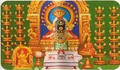
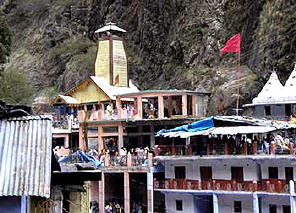
Amidst the dramatic mountainscapes of the majestic Kedarnath range stands one of the twelve ‘Jyotirlingas’ of Kedar or Lord Shiva. Lying at an altitude of 3584 mts. on the head of river Mandakini, the shrine of Kedarnath is amongst the holiest pilgrimages for the Hindus.The origin of the revered temple can be found in the great epic - Mahabharata. According to legend, the Pandavas sought the blessings of Lord Shiva to atone their sins after the battle of Mahabharata. Lord Shiva eluded them repeatedly and while fleeing took refuge at Kedarnath in the form of a bull. On being followed, HE dived into the ground, leaving behind HIS hump on the surface. This conical protrusion is worshipped as the idol in the shrine.The remaining portions of Lord Shiva are worshipped at four other places - the arms (bahu) at Tungnath, mouth (mukh) at Rudranath, navel (nabhi) at Madmaheshwar and hair (jata) at Kalpeshwar. Together with Kedarnath, these places are known as the Panch Kedar.
The lingam at Kedarnath is pyramidal, unlike its usual form. A status of Nandi – the celestial bull stands at the entrance of the temple and exquisitely carved images adorn the interiors of the temple.
During the winters, the shrine is submerged in snow and hence is closed. The ideal time to visit is between May to October. Kedarnath is reached through a 14 km. long trek from Gaurikund.
Location
Kedarnath is situated in the Uttar Kashi district of the northern state of Uttaranchal. Very close to the Indo-Chinese border, it is the source of the Mandakini River. It is couched in the scenic locales of the Garhwal Himalayas at 3583 meters above sea level. It is very cold in the winters with the ground being covered with snow. In the summers, the mercury barely crosses the 20°C mark. The place experiences about 150 cm of rainfall during the monsoons and so the best time to visit is between May and October. Kedarnath is near to Rishikesh (234 km) and Dehradun (250 km).
History
According to legend, Lord Shiva wished to elude the Pandavas, who had come to seek penitence for having killed their kin in the battle of Kurukshetra. He took refuge in Kedarnath in the form of a bull. Bhima, one of the Pandava brothers, found Shiva amongst a herd of cattle. Having identified the meanest and most arrogant of the herd as Shiva, Bhima is said to have grabbed him by the hindquarters. What remains at the shrine in Kedarnath is the rear end of the bull, with the rest of its body scattered throughout the Garhwal. Shiva dived into the ground leaving behind him a hump on the surface. This conical protrusion is worshipped as the idol. It is the main site of the Panch Kedar temples.
There are Four Other Kedars
Mythological Myth
Legend has it that when the Pandavas sought penance following the great war of the Mahabharata they came in search of Lord Shiva. Arriving at this site they found that Shiva had elusively taken the form of a bull. Bhim the strongest of the Pandavas went after Shiva who dived deep into the ground. Only Shiva's tail was left in Bhim's hand. This spot is known as the Kedarnath and is also considered the main Kedar. The rest of Shiva's body emerged at four other places in Garhwal - Tunganath, Madhyamaheshwar, Kalpeshwar and Rudranath.
These five Kedars are worshipped as Panch Kedars
- Madhyamaheshwar
- Tunganath
- Kalpeshwar
- Rudranath
Mythological Myth
Legend has it that when the Pandavas sought penance following the great war of the Mahabharata they came in search of Lord Shiva. Arriving at this site they found that Shiva had elusively taken the form of a bull. Bhim the strongest of the Pandavas went after Shiva who dived deep into the ground. Only Shiva's tail was left in Bhim's hand. This spot is known as the Kedarnath and is also considered the main Kedar. The rest of Shiva's body emerged at four other places in Garhwal - Tunganath, Madhyamaheshwar, Kalpeshwar and Rudranath.
These five Kedars are worshipped as Panch Kedars
- Tungnath
Shiva's arms came out at Tungnath. The Tungnath temple is at an altitude of 3,680 m and is the highest Shiva shrine among the Panch Kedars. However it is the easiest to reach from Chopta, the nearest road head. - Rudranath
Shiva's face is worshipped at the Rudranath temple. It is about 2,286 m above sea level and is 23 km from Gopeshwar. 5 km of the distance is motor able and 18 km is on foot. The trek passes through wild orchards and picturesque bugyals (meadows) and involves trekking over high ridges (sometimes 4,000 m). The temple site provides magnificent views of Hathi Parvat, Nanda Devi, Nanda Ghungti, Trishuli and many other peaks. There are a number of holy kunds or ponds near the Rudranath temple like Suryakund, Chandrakund, Tarakund. The entire area is utterly enchanting and unmatched in scenic beauty. Anusuya Devi temple is located on the trek to Rudranath involving an additional trek of 3km.
General Information :-
Area : 3 sq. km.
Climate : Winter: Sep. to Nov. cold during the day and chilly at night.
Summer: May - August- Cool during the day and cold at night.
Rainfall : 1475 mm.
Best Season : May to October except monsoon.
Clothing : Light woollens in summer. Heavy woollens in winter.
Language : Hindi, Garhwali and English.
Attractions of Kedarnath
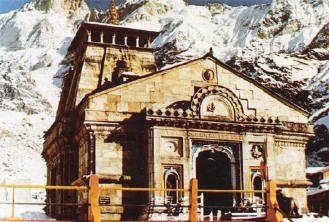
- Kedarnath Temple
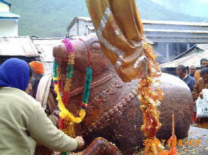
The present temple, built in 8th century A.D. by Adi Guru Shankaracharya lies adjacent to the site of an ancient temple built by Pandavas. The walls of the exquisitely architectured temple are embellished with figures of deities and scenes from mythology. The temple has a conical lingam - the main idol, a statue of Nandi - the celestial bull, a 'garbha grab' for worship and a 'mandap' for assemblies of piligrims and visitors. The temple is believed to be more than 1000 years old. - Shankaracharya Samadhi
Behind the Kedarnath Temple lies the samadhi or the final resting place of Adi Guru Shankaracharya. It is believed, after establishing the four dhams in India, he went for his samadhi at an early age of 32 years.
Excursions
Chorabari (Gandhi Sarovar) (2 kms.)
A small lake from where Yudhishthir, the eldest of the Pandavas, is believed to have departed to heaven. The floating ice on the sparkling waters of the lake is a fascinating sight.
Chorabari (Gandhi Sarovar) (2 kms.)
A small lake from where Yudhishthir, the eldest of the Pandavas, is believed to have departed to heaven. The floating ice on the sparkling waters of the lake is a fascinating sight.
- Vasuki Tal (6 kms.)
A picturesque lake, 4,135 mts. above sea level is encircled by lofty mountains and offers a commanding view of the Chaukhamba peaks. - Gaurikund (14 kms.)
The trekking base to Kedarnath. A temple dedicated to Gauri and thermal springs of medicinal value are noteworthy. - Sonprayag (20 kms.)
The confluence of Son Ganga and Mandakini rivers. The road to Triyuginarayan diverts from here. - Triyuginarayan (25 kms.)
A 5 kms. trek from Sonprayag, it is the mythological venue of the marriage of Lord Shiva and Goddess Parvati.An eternal flame, which is said to have been a witness to the marriage, burns in front of the temple even today. - Guptkashi (49 kms.)
The temples of Ardhnarishwar and Vishwanath are noteworthy. - Ukshimath (60 kms)
Winter home of the deity of the Kedarnath Temple and the seat of the Rawal of Kedarnath. - Agastyamuni (73 kms.)
Famous for the temple dedicated to sage Agastya. - Chandrashila (93 kms.)
The Chandrashila peak provides a rare view of snow-clad peaks. The rhododendron Forests and alpine meadows dominate the trek fromTungnath to Chandrashila. - Deoria Tal (68 kms.)
Sari village is the last bus terminus on Chopta-Ukhimath road from where a 2 kms. trek leads to Deoria Tal. This beautiful lake at an altitude of 2,438 mts. gives the spectacular reflection of snow capped peaks in the lake water. Ideal spot for angling and bird watching.
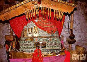
Photos of Badrinath
 |  |
| Kedarnath Temple | Nandi - Kedarnath |
How to Reach Kedarnath:
| Air | : | Nearest airport is Jolly Grant, Dehradun, 239 km. |
| Rail | : | Nearest railway station is Rishikesh, 221 km. |
| Road | : | Kedarnath is approachable on foot, 14 km from Gaurikund, which is connected by road with Rishikesh, Kotdwar, Dehradun, Haridwar and other important hill stations of Garhwal and Kumaon hills. |
| Local Transport | : | Horses, dandies and ponies are available at Gaurikund for going and carrying luggage to Kedarnath. |
ACCOMMODATION
Dharamshalas, Ashrams, Cottages and Tourist Rest House offer a comfortable stay.An Important Note
During the winters, the shrine is submerged in snow and hence is closed. The ideal time to visit is between May to October. Kedarnath is reached through a 14 km. Long trek from Gaurikund.Tourist Information Centre ( Kedarnath )
Rishikesh (Yatra Office), AGM (Tourism), GMVN Ltd., Tourist Information Centre,
(Advance Reservation Centre)
Shail Vihar, Haridwar By Pass Road, Rishikesh Pin: 249201.
Tel.: 0135-2431793, 2431783, 2432648, 2430799.
Fax: 0135-2430372.
Email: yatra@gmvnl.com, yatraoffice@sancharnet.in.
Badrinath
The Abode Of Lord Vishnu
Cradled in the twin mountain ranges of Nar and Narayan is the holiest of the four main shrines, Badrinath along the left bank river Alaknanda. With the splendid Neelkanth mountains as the backdrop, it is an important destination on the scared itinerary of every devour Hindu. Once the spot was carpeted with 'badris' or wild berries and hence was famous as 'Badri Van'.
Cradled in the twin mountain ranges of Nar and Narayan is the holiest of the four main shrines, Badrinath along the left bank river Alaknanda. With the splendid Neelkanth mountains as the backdrop, it is an important destination on the scared itinerary of every devour Hindu. Once the spot was carpeted with 'badris' or wild berries and hence was famous as 'Badri Van'.
Badrinath is considered the holiest of the four important shrines in Garhwal. The town is at an altitude of 3,133 m. above sea level, situated on the left bank of river Alaknanda and exactly between the two mountains Nara and Narayan. The shrine is dedicated to Vishnu, the preserver and falls in the religious itinerary of every devout Hindu.
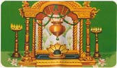
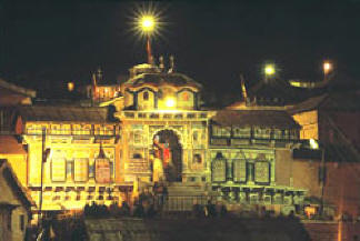
The present temple was built about two centuries ago by Garhwal Kings. It is a conical structure, 15 m. tall and has small cupola of a gilt bull and spire. There are 15 idols in the temple complex, each sculpted in black stone. The principal idol represents Vishnu in a meditative posture and is flanked by Nara-Narayan. Legend dates it prior to the Vedic age though it is believed to have been re-established by Adi Shankaracharya, an important Hindu saint in 8th century A.D. Some of the other images include Laxmi (Vishnu's consort), Garud (Vishnu's mount), Shiva & Parvati and Ganesha.
The temple has been renovated several times due to damages by avalanches. It looks fairly modern now due to the colourful "Singh Dwara" or the main entrance gate. It has three parts- Garbha Griha (the sanctum sanctorum), Darshan Mandap (for pujas) and Shobha Mandap (for devotees to assemble). The revered shrine is still alive with myriad legends from mythology. Its sanctity is emphasised in the ancient scriptures as "There are many sacred spots of pilgrimage in the heavens, earth and the nether world, but there has been none equal to Badri, nor shall there be".
Mythological Legend of Badrinath
Legend has it, when the Ganga was requested to descend to earth to help suffering humanity, the earth was unable to withstand the force of its descent. Therefore the mighty Ganaga was split into twelve holy channels. Alaknanda was one of them that later became the abode of Lord Vishnu or Badrinath.
The temple of Shri Badrinathji on the banks of the Alaknanda river, dates back to the vedic times. Situated at an altitude of 3,133 mts., the present temple is believed to have been built by Adi Guru Shankaracharya- an 8th century's philosopher-saint, who also established a 'math' here. Also known as 'Vishal Badri', Badrinath is one of the Panch Badris
Besides the main temple of Badrinath there are four other smaller badri temples. These are collectively called the panch badris or five badris. Very few pilgrims however, visit the other four Badri temples.
- Yogadhyan Badri (1920 m.)
Closest to the main temple of Badrinath lies this tiny, sleepy hamlet which remains unnoticed by most pilgrims and is the winter home for the idol at Badrinath. Pandukeshwar is also an important archaeological site. Some years ago, four ancient metal foils engraved with a description of several kings in the region were discovered here. Believed to be over 1500 years old, these foils are kept at Joshimath, 30 km downstream. - Bhavishya Badri (2,744 m.)
The bhavishya or future badri is situated at Subain near Tapovan, about 17 km east of Joshimath. According to Hindu belief, when evil is on the rise in this world, the two mountains Nara and Narayan at Badrinath will close up on each other and destroy the route to the present Badrinath. This would also mark the end of the present world and the beginning of a new one. Lord Badrinath will then appear at the Bhavishya Badri temple and be worshipped here instead of at the present one. - Bridha Badri or the 'Old Badri'
Bridha Badri or the 'old Badri' is the third temple about 7 kms short of Joshimath, on the main Rishikesh-Badrinath motor road at Animath. It is believed that Badrinath was worshipped here before its enshrinement by Shankaracharya at the main Badrinath seat. The temple of Bridha Badri is open throughout the year. - Adi Badri
Adi Badri is the farthest from the other four badris. It is approachable from Karnaprayag by a motorable road enroute Ranikhet. The temple complex has 16 small temples with intricate carvings.
Seven of these temples belong to the late Gupta period. Local tradition assigns these buildings to Shankaracharya. The main temple is distinguished by a pyramid shaped raised platform, with a black stone idol of Vishnu.
General Information :-
| Area: | 3 sq km. |
| Altitude: | 3133 m. |
| Season: | From opening to closing, generally from April to November. |
| Clothing: | Heavy woolen garments required through out. |
Attractions of Badrinath
- Badrinath Temple
On the right bank of Alaknanda lies the sacred spot perched at an altitude of 3,133 metres above the sea level. Encircled by a beautiful valley, the 15mtrs. High temple is dedicated to Lord Vishnu, it is built in the form of a cone with a small cupola of gilt bull and spire. Built by Adi Guru Shankaracharya - the philosopher-saint of the 8th century, the temple has been renovated several times due to damage by avalanches. Its colourful 'Singh Dwara' or the main entrance gate gives it a new, modern look.
The temple divided into three parts - the 'garbha griba' or sanctum sanctorum, the 'darshan mandap' where the rituals are conducted and the 'sabha mandap'where devotees assemble.The complex has 15 idols. Especially attractive is the one metre high image of Badrinath, finely sculpted in black stone. It represents Lord Vishnu seated in meditative pose.
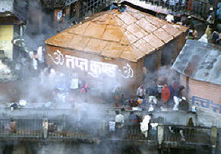
- Tapt Kund
Devotees take a holy dip in the natural thermal springs on the banks of the river Alaknanda, before entering the Badrinath Temple. The water of the kund is believed to have medicinal properties. - Hemkund Sahib (43 kms.)
Near the Valley of Flowers is the holy lake Hemkund- an important pilgrimage of the Sikhs and Hindus. Along its shores is the sacred Sikh Shrine where Guru Gobind Singh, the tenth Guru unified with God after prolonged mediation in his previous birth.
Nearby is the Lakshman Temple where Lakshman - the brother of Lord Rama performed his penance. The reflection of surrounding snow-clad peaks in its placid waters offers a scenic sight. - Brahma Kapal
A flat platform on the bank of river Alaknanda where Hindus perform propitiating rites for their deceased ancestors. - Neelkanth
A Pyramidical-shaped snowy peak towering above Badrinath, popularly known as the 'Garhwal Queen'. - Mana Village (4 kms.)
Inhabited by Indo-Mangolian tribe, it is considered to be the last Indian village before Tibet on this route. Nearby are Vyas Gufa- the rock cave of saint Ved Vyas, the writer of Mahabharata; Bhim Pul- a natural bridge over the Saraswati river and Vasundhara Falls- a 122 mts. high waterfall- all forming and important part of the pilgrimage to Badrinath. - Mata Murti Temple (3 kms.)
On the right bank of Alaknanda stands the temple dedicated to the mother of Sri Badrinathji. - Alka Puri (15 kms.)
The source of Alaknanda river from the glacier snouts of Bhagirath- Kharak and Satopanth glaciers. - Satopanth (25 kms.)
A three cornered lake with a circumference of about 1 km., situated at an elevation of 4,402 mts. above sea level. It is named ater the Hindu triad- Brahma, Vishnu and Mahesh, who are believed to occupy one corner each of the lake. The trek is hazardous with dramatic landscapes. An experienced guide is advisable. Govindghat (25 kms.)
The confluence of Alaknanda and Lakshman Ganga rivers. It has an imposing Gurudwara named after Guru Gobind Singh. - Joshimath (44 kms.)
The winter home of Shri Badrinathji is situated on the slopes above the confluence of Alaknanda and Dhauliganga. It is one of the four 'maths' established by Adi Guru Shankaracharya. - Panch Prayag
The five important confluences- Deoprayag, Nandprayag, Rudraprayag, Karnaprayag and Vishuprayag, form the Panch Prayag. - Deoprayag
The confluence of Alaknanda and Bhagirathi rivers. Ancient stone scriptures are found here. Important pilgrim spots are Shiv Temple and Raghunath Temple. - Rudraprayag
The confluence of Alaknanda and Mandakini rivers. The temples of Rudranath and Chamunda Devi are noteworthy. - Nandprayag
The confluence of Alaknanda and Mandakini rivers. The Gopalji Temple is worth a visit. - Karnaprayag
The confluence of Alaknanda and Pindar rivers with temples of Uma and Karna. - Vishnuprayag
The confluence of Alaknanda and Dhauliganga rivers. An ancient temple of Lord Vishnu stands here by a pool called Vishnu Kund. - Srinagar
The old capital of Garhwal, it is an important cultural and educational centre. Places to visit include Kamleshwar and Kilkeshwar temples and the Shankar Math.
Photos of Badrinath
 |  |
| Tapt kund - Badrinath | Badrinath Temple |
How to Reach Badrinath:
Jolly Grant (317 kms.)
Railhead
Rishikesh (300 kms.), Kotdwar (327 kms.)
Road
Well connected to Rishikesh, Haridwar, Dehradun, Kotdwar and other hill stations of Garhwal and Kumaon region.
Tourist Information Centre for Badrinath
Tourist Office, Bus Station,
Gopeshwar, Tel.:01372-252468.
Yatra Office : Yatra Office, GMVN Ltd., AGM (Tourism), Modern Reception Centre.
(Advance Reservation Centre) Shail Vihar, Haridwar Bye Pass Road, Rishikesh - 249201.
Tel.: 0135-2431793, 2432648, 2430799, 2430357(R).
Fax: 0135-2430372.
Email: yatra@gmvnl.com, yatraoffice@sancharnet.in
Permalink